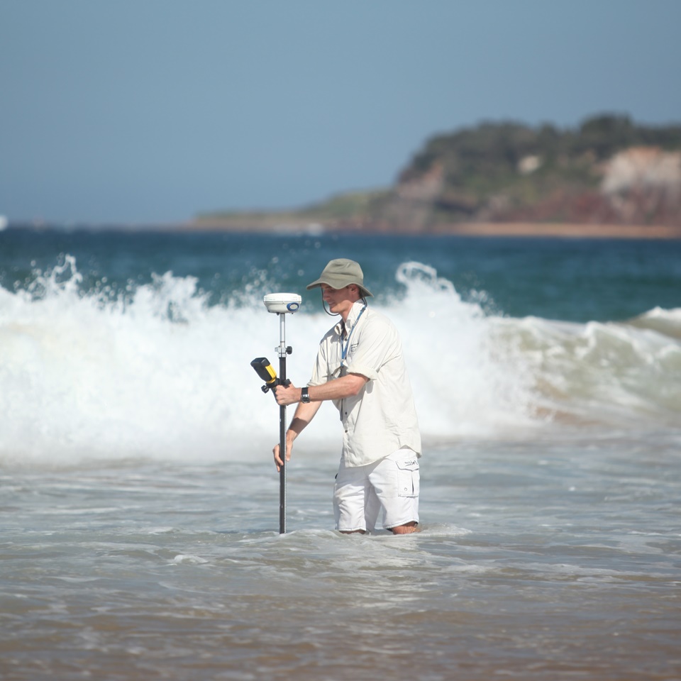
RTK-GPS surveying at Narrabeen-Collaroy Beach, 2015
Long-term datasets that record and quantify the variability,
changes and trends in morphology observed at sandy
beaches are rare. A monthly beach profile survey program that
commenced in April 1976 at Narrabeen located on Sydney's
Northern Beaches is one of a limited number of sites globally
where on-going and uninterrupted beach monitoring now spans
multiple decades.
In the 1970s and 1980s the growing database of beach surveys
at Narrabeen was key to the pioneering work by Australian
coastal geomorphologists that resulted in the formulation of
a morphodynamic Beach State Model. This
model remains today as the standard classification scheme used
by coastal scientists worldwide to describe different natural
beach states, their characteristic morphodynamic process
signatures and associated wave and sediment environmental
controls.
During the 1990s related studies at Narrabeen included a focus
on surfzone rip currents and the emergence of new insight to
the associated hazards to beach swimmers. At the turn of the
21st Century the record of beach changes at Narrabeen had
extended to sufficient length that longer-term cycles and
underlying trends in beach behaviour began to be
revealed. This prompted significant new interest in the wider
use of the Narrabeen survey dataset to further identify and
explore potential linkages between regional-scale climatic
forcing and sandy coastline response. At the same time,
recognition within the research community that regional-scale
wave climates can be expected to change and sea levels in the
coming decades will continue to rise, helped strengthen the
awareness of the fundamental importance of sustained coastline
monitoring programs. In particular, the monthly observations
from Narrabeen provided an all-too-rare data resource to
calibrate and test new models aimed at developing better
prediction tools of present and future variability and changes
along sandy coastline worldwide.
The monthly beach profile survey program at Narrabeen reached
its 40-year milestone in April 2016. Online access to this
dataset now facilitates its unrestricted use by the
international coastal research community. It is envisaged that
open access to these data may provide additional stimulus to
coastal morphodynamic modellers to develop, test and (it is
hoped) significantly advance the next generation of beach
erosion-recovery hindcasting and forecasting tools. It is also
hoped that this website can be a useful educational resource
for students and teachers. As a discipline, our ability to
predict anticipated coastal changes in the context of a
changing climate is presently in its relative infancy. In the
meantime, as the current custodians of this unique resource,
it is the intention that collection of monthly profile data at
Narrabeen will continue for the foreseeable future and be
provided here, as our contribution to generations who follow.
Prof. Andrew Short surveying at Narrabeen, 1976
The beach monitoring program at Narrabeen can be divided into
two distinct periods: the first three decades when a simple
and traditional survey technique was employed; and from 2004
onwards when the monitoring program was significantly
expanded, and the use of new and emerging survey technologies
have been progressively implemented. A time-line and summary
of the various survey methods employed is described below.
1976-2006: historical profile surveys
The years between 1976 and 2006 constitute the period of
conventional profile line surveys undertaken by Professor
Andrew Short and volunteers of the Coastal Studies Unit,
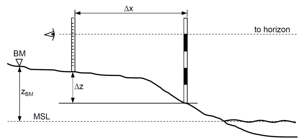
University of Sydney, employing the Emery method. This
simple, rapid and low-cost technique uses a measuring tape for
cross-shore distance, and vertical elevation changes are
calculated using line-of-sight between two graded rods and the
horizon. Commencing with the landward rod on a fixed
benchmark, the distance between the two rods is first measured
using the measuring tape. The change in elevation between the
two rods is then calculated by using the line-of-sight with
the horizon and markings on the rods as a reference. This
process is repeated at each subsequent measurement point along
the entire length of the cross-shore profile line.
The Emery method for measuring beach profiles
The monitoring program during the 1970s based on this use of
the Emery method initially comprised fortnightly cross-shore
profile surveys at a total of fourteen profile lines along the
embayment. Each profile line was surveyed at spring low tide
from a fixed benchmark located in the stable dune area down to
a swimming depth within (and sometimes beyond) the surf
zone. This labour-intensive approach typically extended each
surveyed profile to depths of 1 - 4 m below mean sea level,
depending on the prevailing surf conditions. The cross-shore
spacing of each measurement was 10 m.
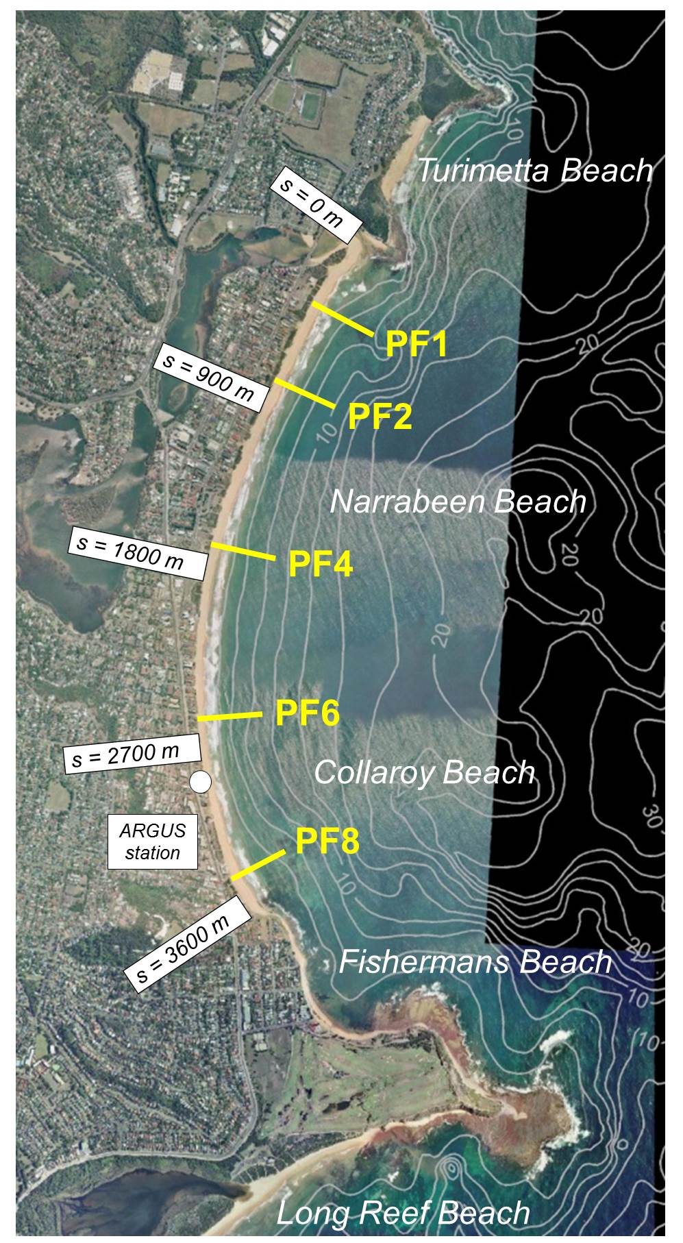
Following the first few years of these fortnightly surveys at
fourteen profile lines, a pragmatic decision was made to
reduce and focus on-going effort to achieve monthly surveys at
a lesser number of five representative profile lines. These
five profiles that continue to the present day are numbered 1,
2, 4, 6 and 8 (north to south, hereafter identified as PF1,
PF2, PF4, PF6 and PF8); their non-sequential numbering
corresponds to the original numbering scheme when 14 profiles
were surveyed. The seaward survey limit for each of these five
representative profiles was also changed to the more easily
achievable intersection with mean sea level (i.e.,
approximately wading depths). These early and pragmatic
decisions to limit the number and cross-shore extent of each
profile line are undoubtedly the key reasons why monthly
surveys were subsequently achieved by the same personnel
during the ensuing three decades.
2004-present: new survey techniques
Recognising the unique and growing value of the Narrabeen
survey dataset worldwide, beginning in 2004 efforts were
initiated by the UNSW Water Research Laboratory to secure,
improve and expand the monitoring program into the future
through the use of new survey technologies. This commenced in
July 2004, with the decision to transition the historical
profile line surveys from the Emery method to the use of
high-accuracy RTK-GPS technology (vertical accuracy ≈ ± 0.03
cm). Following an 18-month validation period during which
surveys were undertaken concurrently using the Emery method
and RTK-GPS, the use of RTK-GPS as the standard survey method
for the five profile lines was adopted in August 2006. The
cross-shore resolution of each profile survey was also
increased at this time from the original 10 m measurement
spacing to near-continuous (i.e., approximately every 0.10 m
cross-shore).
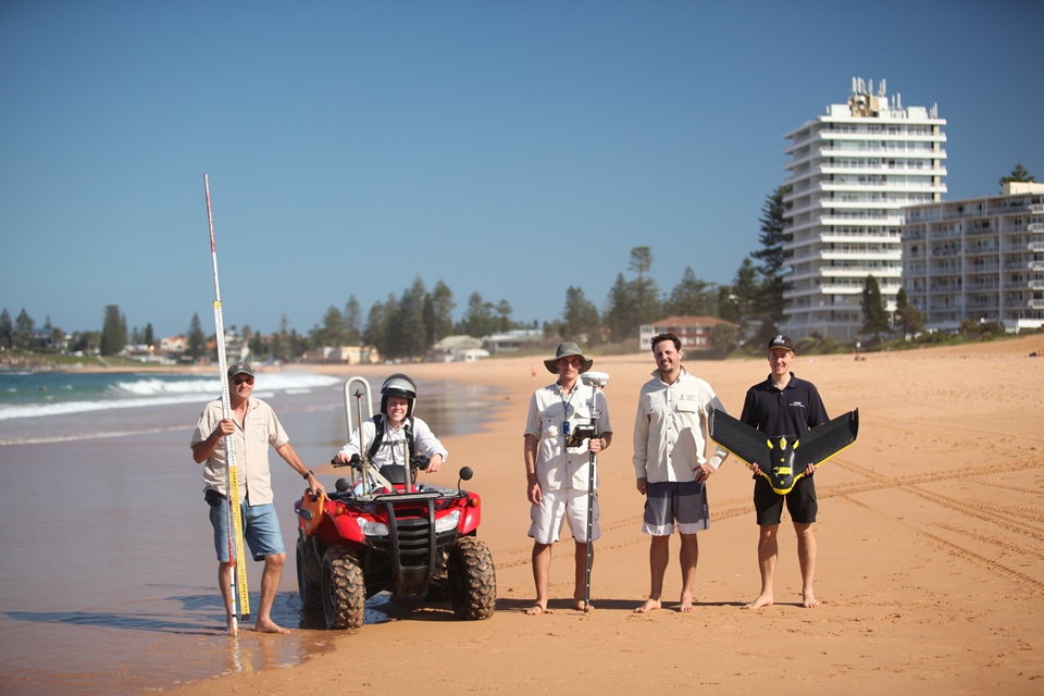
Narrabeen-Collaroy coastal monitoring team, 2015
At the same time as the use of RTK-GPS was implemented in
early 2004, an Argus coastal imaging station was installed
atop the 44 m high Flight Deck apartment building at South
Narrabeen. Since this time, this station has continuously
collected hourly daylight images of the southern sector of the
beach from five separate cameras (the field of view
encompassing PF6 and PF8). Automated algorithms are used to
measure high-frequency shoreline variability and other beach
and surfzone features.
Since 2004 several additional survey techniques have been
progressively implemented at Narrabeen to complement the
on-going monthly profile surveys detailed here, with the
objective to build an expanded future dataset with which to
gain greater understanding of beach morphodynamics at more
detailed spatial and temporal resolutions. These techniques include:
Monthly three-dimensional RTK-GPS surveys of the
entire subaerial beach using an all-terrain vehicle
A second Argus coastal imaging station installed at
the northern end of the beach
Pre- and post-storm three-dimensional Airborne Lidar
surveys of the entire beach and dune systems
A permanent fixed Lidar system scanning a single
profile line day and night at a frequency of 5 Hz
Pre- and post-storm three-dimensional surveys of the
entire beach and dune systems using an Unmanned Aerial
Vehicle
Single and multi-beam bathymetric surveys of the surf
zone and offshore bathymetry
Location of the five profile lines within the Narrabeen-Collaroy embayment
The coastline of southeastern Australia includes over 700
embayed sandy beaches averaging 1.3 km in length separated by
rocky headlands. The 3.6 km-long Narrabeen-Collaroy embayment
(hereafter simply referred to as ‘Narrabeen’) is situated
within the Northern Beaches region of metropolitan
Sydney. Locally, the sandy beach that spans the entire
embayment is referred to as Narrabeen beach towards the north
and Collaroy beach in the south, with the small section of
beach adjacent to the prominent headland at the extreme
southern end called Fishermans beach (see right).
The beach sediments at Narrabeen were deposited as a
regressive barrier in the mid- Holocene approximately 300 m
landward of the present-day shoreline. The barrier
subsequently prograded through a series of foredune ridges,
with the most seaward ridge of the modern embayment dated at 3
ka. The granulometry is approximately uniform along the beach
and characterized by fine to medium quartz sand (D50 ≈ 0.3 mm)
with ~30% carbonate fragments. A lagoon now backs the northern
half of the barrier and is connected to the ocean via a
shallow narrow (~50 m-wide) inlet at the embayment’s northern
extremity that intermittently opens and closes to the ocean.
The adjacent headlands and curvature of the embayment result
in a distinctive alongshore wave energy
gradient. Dissipative-intermediate beach conditions typically
prevail in the north, transitioning to lower energy and
intermediate-reflective beach conditions towards the
south. The northern end of Narrabeen is characterised by
single-bar rhythmic bar-beach (RBB) to transverse bar-rip
(TBR) intermediate beach states and a subaerial berm that
varies up to 80 m in width, backed by a vegetated foredune up
to 9 m in height above mean sea level (MSL). At the southern
end of the embayment urban development has encroached on to
much of the foredunes, which reach only 3 to 4 m in height,
and the beach consists of a berm that varies up to 60 m in
width and a single-bar system that tends towards the lower
energy low-tide terrace (LTT) and reflective beach states.
Tides are microtidal and semidiurnal with a mean spring tidal
range of 1.3 m. The deepwater wave climate for the Sydney
region is of moderate to high wave energy (mean Hs ≈ 1.6 m and
Tp ≈ 10 s) and dominated by persistent long period swell waves
from a SSE direction. These swell waves are generated from
mid-latitude cyclones that propagate approximately 5-9 times
per month across the southern Tasman Sea, south of mainland
Australia. Superimposed on these background swell waves are
storm events that are typically defined for this region by a
significant wave height threshold of 3 m, corresponding to the
0.95 quantile. These storm waves are derived from a number of
sources and directions: tropical cyclones from the northeast,
east-coast lows from the east and intensified mid-latitude
cyclones from the south. The wave climate exhibits a mild
seasonal cycle, with high-energy mid-latitude cyclones and
east-coast lows more prominent in the Austral winter months
and low-energy short-period seas derived from local
north-easterly sea-breezes more prominent in the Austral
summer. At inter-annual time scales, the wave climate is
influenced by the El Niño/Southern Oscillation (ENSO), with La
Niña periods typically having a more energetic and easterly
wave climate and El Niño periods a less energetic and more
southerly wave climate.
The distinct wave energy gradient in the local shallow-water
wave climate at Narrabeen is to a large degree a result of the
sheltering of southerly waves by the 1.5 km Long Reef Point
headland that forms the embayment’s southern
extremity. Numerical wave modeling indicates breaking wave
height is approximately 30% higher at the northern end
compared to the southern end for average wave conditions. This
situation is reversed, however, for northeast waves, with
breaking wave heights approximately 30% larger in the south
relative to the north. An equivalent reversal in the wave
angle of incidence is also observed, with southerly waves
resulting in northerly-directed alongshore currents and
northeast waves resulting in southerly-directed alongshore
currents.
Data Descriptor
In addition to the growing dataset of monthly beach profiles
available at this web site, an archived dataset for the fixed
period 1976 – 2014 is described and detailed in the
accompanying peer-reviewed Data Descriptor
paper, published in the journal 'Scientific Data' (Nature Publishing
Group). This comprehensive dataset includes monthly subaerial
profiles, bathymetries, and time-series of astronomical tide
and offshore wave forcing transformed to the inshore location
corresponding to each of the individual survey transects.
Acknowledgements
Since 2004 the continuing beach monitoring program has been
funded by the Australian Research Council (Discovery and
Linkage), Warringah Council, NSW Office of Environment and
Heritage (OEH), SIMS Foundation, the UNSW School of Civil and
Environmental Engineering and the UNSW Faculty of
Engineering. OEH provided the bathymetry data included
here. The Sydney waverider buoy data used for offshore to
inshore wave transformation is funded by OEH and managed by
Manly Hydraulics Laboratory. The SWAN lookup table to complete
this transformation was initially created by Mr Ed
Kearney. CSIRO (especially Dr Mark Hemer) is acknowledged for
undertaking and providing the CAWCR wave hindcast
dataset. Brad Morris of OEH provided the Sydney tide
measurements for T_Tide analysis. Brett Miller at UNSW
provided guidance on the creation of this website. And
finally, we would like to thank all those individuals who have
joined us on the beach to assist with the monthly surveys
during the past 4 decades.